Back Prioldi Trefynwy Breton Monmouthské převorství Czech Priordy Trefynwy Welsh Priorejo de Monmouth Esperanto मॉनमाउथ प्रायरी Hindi Monmouthi kolostor Hungarian Coenobium Monemutense Latin Монмутский монастырь Russian
| Monmouth Priory | |
|---|---|
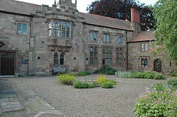
 The Priory, showing the oriel window | |
 | |
| General information | |
| Type | Benedictine priory |
| Address | Priory Street |
| Town or city | Monmouth |
| Country | Wales |
| Coordinates | 51°48′48.8″N 2°42′50.9″W / 51.813556°N 2.714139°W |
| Renovated | 2002 |
| Renovating team | |
| Architect(s) | Keith Murray |
Monmouth Priory, in Priory Street, Monmouth, Wales, is a building that incorporates the remains of the monastic buildings attached to St Mary's Priory Church. The priory was a Benedictine foundation of 1075, and parts of the mediaeval buildings remain.[1] The buildings were substantially redeveloped in the nineteenth century for use as St Mary's National School,[1] and now form a community centre. The complex is a Grade II* listed building as of 27 June 1952. It is one of 24 sites on the Monmouth Heritage Trail.